The Bell II Lodge is a popular stop for fuel and lodging on this part of the Cassiar. Notice the grass roof in the third picture down.


The Burrage River, with rock pinnacles in the water and on the bank (on the right side of the picture):

We stayed at the Mountain Shadow RV Park in Iskut BC. Isn't it beautiful?

Bill and Barkley step into another dimension on the park's nature trail to Kluachon Lake.

A type of Bluebell:


Sandpipers:

Kluachon Lake:


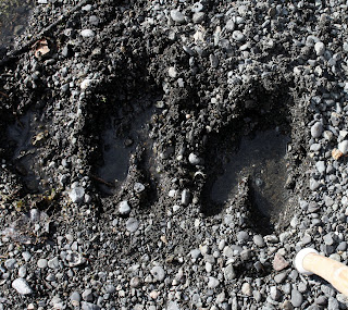
Moose tracks:

A moose in the lake, as seen from our RV site (with a lens that doesn't have enough zoom):

A red fox in the field between our RV and the lake, on the morning of June 8th, before we headed north once more:


Marking the Arctic - Pacific Divide:


About 70 miles past the continental divide, a red fox carrying a squirrel ran across the road in front of us. We didn't get a picture of that, but we did get a few more wildflower pictures.


We think these are Stone Sheep. Bill did some quick maneuvering and braking to avoid hitting them.


It's raining again!

Common Loons at the Blue Lakes rest area:


Another gravel road, this one under construction:

About two miles after we crossed from British Columbia into the Yukon Territory, the Cassiar Highway ended and we turned west onto the Alaska Highway. Twenty-five miles later, we stopped for the night and found a fantastic site in the Big Creek Yukon Government Campground. It was a huge pull-through right above the creek.


Lupines at our site:


No comments:
Post a Comment